Cameron LNG Facility Shoreline Stabilization
Cameron Parish, Louisiana
Beard/Cameron LNG
Project Overview
Royal partnered with the construction contractor to provide design-build services for approximately 6,300 linear feet of rubble-mound shoreline stabilization for an LNG facility located on the Calcasieu Ship Channel (CSC) in Cameron Parish, LA. With an average shoreline recession rate of 13 feet per year experienced between 1998 and 2013, the goal of this project is long-term stabilization of the facility’s shoreline, primarily against the erosive effects of passing ships, which are expected to increase in both size and frequency over the next 20 years with LNG development along the CSC.
Project Work & Royal Solutions
Royal initiated design efforts by first procuring geotechnical and topo-bathymetric field data collection and by observing hydrodynamics at the project shoreline during the passage of deep-draft vessels. With the collected/observed field information, Royal conducted a three-phase numerical modeling program to obtain design requirements associated with: (1) vessel-induced hydrodynamics; (2) wind-generated waves and wave run-up; and (3) tidal hydrodynamics. Two-dimensional vessel-induced hydrodynamics were simulated with the non-hydrostatic module of the Deltares software XBeach, for five classes of ships projected to characterize vessel traffic in the CSC between Cameron and Lake Charles over the next 20 years. Two-dimensional wind-generated wave fields were simulated with the Deltares software Delft3D-Wave for the local 20-year wind magnitude forced from a 180° directional spectrum incident to the project shoreline at 10° intervals. Two-dimensional tidal hydrodynamics were simulated with the USACE software ADH for the 20-year tidal discharge forced from both the flood and ebb directions.
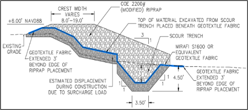
Using outputs from the numerical modeling program, Royal performed engineering calculations to determine the rock size, side slope, crest elevation, and toe-scour protection measures needed for the stabilization structure to resist the 20-year hydrodynamic conditions that were evaluated. Determination of appropriate scour protection was informed by calculation of continuous scour at the toe of the structure due to the hydrodynamics associated with 84,924 discrete inbound and outbound vessel passages in the CSC (spread amongst the five design vessel classes) predicted by a 2015 vessel traffic study commissioned by the Port of Lake Charles. To calculate the resulting scour depth, Royal wrote and implemented a 1D cohesive scour routine based on empirical formulations developed by the FHWA, which was coupled offline to the XBeach hydrodynamic model and populated with depth-varied geotechnical data obtained from the field investigation. Lastly, to complete the typical design template, the appropriate class of geotextile fabric for this application was selected from the 2016 LADOTD Standard Specifications.
Once the development of the typical design template was completed, Royal worked closely with the construction contractor to finalize the detailed design of the 6,300-foot project length with constructability insight provided by the contractor, which were needed in addressing items such as structure tie-ins to existing shoreline infrastructure and the incorporation of excavated earthen material from the toe of the structure into the design section.
Overall, the design of this project was a highly successful collaboration between engineering and construction personnel, promoted by the nature of the design-build contracting mechanism, which resulted in a robustly engineered and constructable product.